
A prolonged dry spell in the Boyne Valley through March, April and May has left grass fields at Brú na Bóinne parched, revealing significant amounts of archaeology beneath the soil. I have been mapping a large area of Newgrange Farm in recent weeks with my drone and some of the aerial images show features that are probable monuments that have not been recorded.
Although there was a drought in 2018, when I discovered Dronehenge and other previously unknown monuments with Ken Williams of Shadows and Stone Photography, this year's dry spell has led to even drier grass fields and more detailed views of tantalising features beneath the soil of Brú na Bóinne.
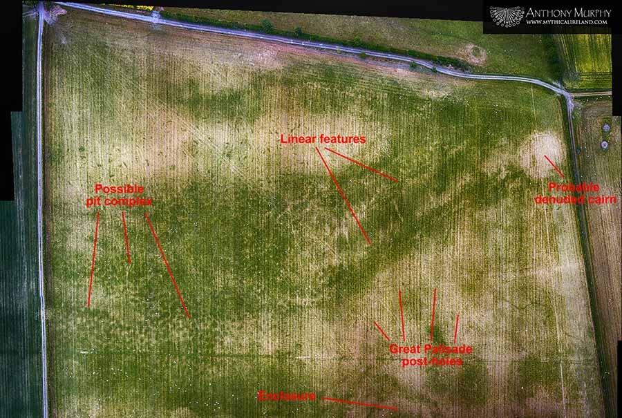
The above image shows a field that lies 300 metres south of the Newgrange monument. It reveals what MIGHT be another pit complex, similar to one in the Dronehenge field revealed by Ken Williams and I in July 2018. Although we cannot be certain if it represents archaeology, is it certainly tantalising. Such pits might be indication of hearths or similar human activity in close proximity to the monuments. The image also shows what is likely to be a denuded cairn (upper right) and, emanating from that cairn and leading off towards the southwest, two very large parallel linear features. These may or may not be archaeological. One is tempted to think they might be cursus monuments, large ceremonial monuments dating to late Neolithic times. In the field just north of this one is a late Neolithic cursus that was part excavated in 2018 and found to have a date of c.2400BC.
Incredibly, the individual post-holes of the Great Palisade are visible in this field. The Great Palisade was discovered in the adjoining Dronehenge field by Ken and I in 2018. The National Monuments Service said in its December 2018 report into the finds that year that this is a huge palisade that might, if it was a complete enclosure, have been about 900m in diameter.

In the same field, towards its southern boundary, is a probable enclosure which has never been seen in so much detail. Only part of it was visible in the aerial images taken in 2018. It has the appearance of a henge but it looks like additions or alterations were made and might represent multiple phases of activity. It looks like a large capital letter G in some of the photos!

The field immediately east of the one containing the possible pit complex, G-shaped enclosure and denuded cairn has significant recorded archaeology, most notably Site A, a mound encompassed by a henge. While there was lots of detail of Site A in the 2018 images, the 2020 aerial photographs show even more of the features.

Visible in great detail in this image is the henge around mound A, with its annexe to the east (south is top in the image). But there are other features, including the eastern segment of the Great Palisade, a possible capsule- or frankfurter-shaped enclosure (said to be a long mortuary enclosure in the National Monuments Service report into the 2018 drought crop marks), an ancient roadway or linear earthwork, and, to the top of the image, part of a subrectangular enclosure with a gap or opening.

I also took a composite vertical aerial photograph of the field immediately east of the Newgrange monument, the one containing what might be a U-shaped Neolithic cursus. The jury is out about the age of this feature. Some researchers believe it might be a garden feature dating some time from the past couple of centuries! But when I compiled this image and did some post-processing of it, I was delighted and surprised to see the footprint of a long-known-about monument not seen in this level of detail before – passage-tomb Z1. This is one of the satellite tombs of Newgrange (the others being sites K and L to the west of the great tomb, and Z and Z1 to the east). A zoom and crop of the image reveals what appears to be a cruciform-shaped stone chamber in the middle of a very small ring (or part circle) of kerb stones.
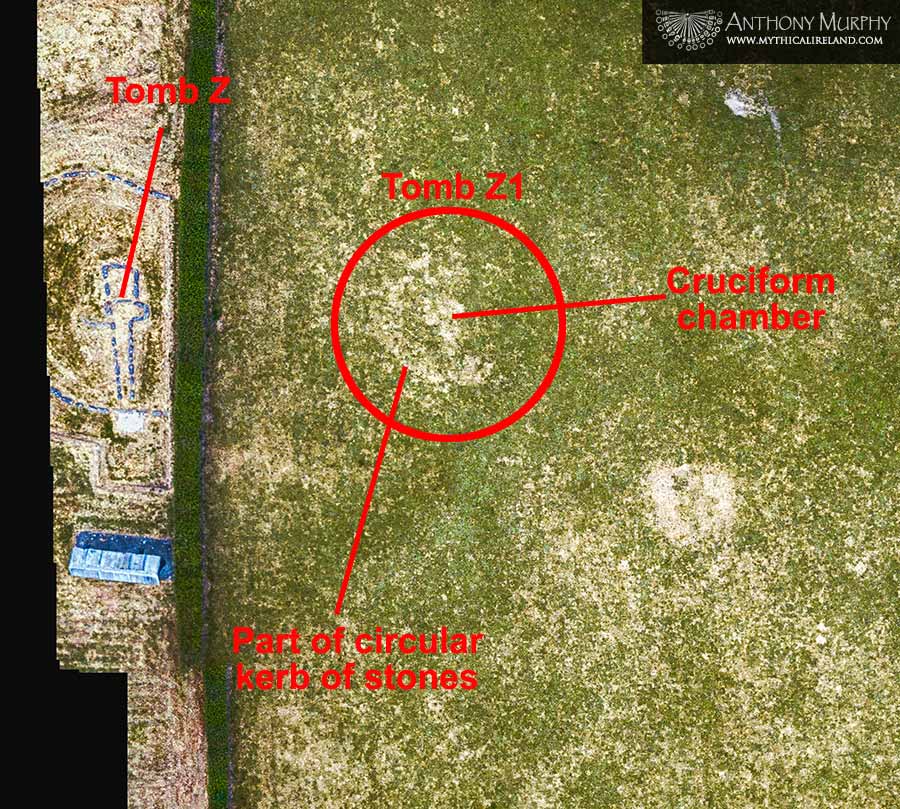
Z1 was first identified as a probable or possible cairn in aerial photography by the late Michael and Clare O'Kelly, who excavated Newgrange in the 1960s and 1970s. A survey of the area revealed a very slight bulge in the surface, indicating a possible mound. Now it looks a lot more likely that the mysterious site Z1 is in fact a small passage-tomb.

Looking towards the west of Newgrange, the field containing the passage-tombs K and L also reveals something quite intriguing in the drone composite image. There is a circle NNW of tomb K, which in all likelihood is some sort of monument.

Near the river, on the lower floodplain of the Boyne, is a complex of sites some of which were previously recorded and some of which were only revealed during the 2018 drought. I call this the "B complex" because it is situated around Mound B, the largest of all the satellite mounds at Brú na Bóinne (known locally in the 19th century as "Dagda's Mound").

The largest of the enclosures here, shown on the left, is the so-called 'Riverside Henge",which was discovered by Ken Williams in 2018. It is by far the largest of all the Brú na Bóinne henges, with an estimated diameter of 160m, according to the National Monuments Service Interim Report into the 2018 drought archaeology.


To the east of the Site A mound and henge is a curious mound called A1 or ME019-050. It was originally recorded by Clare O'Kelly in 1978 as a ploughed-out mound visible in aerial photographs. It appeared as a circular platform in a drone image taken by me in early morning sunlight in late 2017, and shows what appears to be a small mound within another mound.

The latest drone images of this mound show a particularly pronounced parched ring around it, possibly indicating a buried kerb. However, only archaeological digging will reveal its true nature.


Near the river is the impressive henge of the embanked enclosure type known as Site P, labelled "Caiseal Oenguso" by archaeologist Geraldine Stout. It was while flying around Site P on 10th July 2018 that I discovered Dronehenge in the neighbouring field to the west. Currently Site P is showing fantastic detail similar to how it appeared two summers ago.

To the east of Site P and immediately south of Site A is a field containing some curious features. There appears to be what National Monuments Service describes as a "buried figure-of-eight pond" that might also be a quarry. The subrectangular enclosure visible in the large Site A composite near the top of this page is also visible in this image.

Another view of this field is shown below, this time from an oblique angle.
One more site that I felt worthwhile taking a look at was the henge LP2, first discovered by the INSTAR project in 2010 and revealed in fine detail in our drone images during the July 2018 drought. It is currently under a crop of spring barley and some interesting details are revealed.

The image shows a bright solid circle surrounded by a bright ring. This would ostensibly indicate a buried mound surrounded by a denuded embanked enclosure. The monument was known as LP2 in the INSTAR report and was labelled the "Univallate Henge" in the National Monuments Report. It looks very different now compared with July 2018, but this image does appear to indicate that there is a central mound, the exact nature of which has caused some debate.

The strange feature in the centre of LP2 showed up in geophys imagery undertaken for INSTAR. It was described in 2010 as a possible passage-tomb. NMS said in its report that the dark areas shown in the 2018 imagery represented pits and ditches. But there is certainly a case to be made that whatever it is, the central feature is contained within a low mound. As with all these things, only an archaeological dig in the future will reveal its secrets!

Hidden archaeology
The parched fields, mostly grass pasture, have been revealing significant subsurface features, many of which are likely to be archaeological. The story of Brú na Bóinne continues to unfold before our eyes. Heavy rain in the past 24 hours seems to have finally brought an end to the dry conditions and will probably lead to a growth spurt.
Even though this is one of the most intensely studied archaeological landscapes anywhere on earth, there is still much to be revealed about the complexity of its early history. We now know that there was an enormous Late Neolithic phase at Brú na Bóinne, something that was completely unknown in the era of Prof. O'Kelly's excavations at Newgrange in the 1960s and 1970s. LiDAR, geophysics and field walking have revealed much that is hidden, but more recently drones and drought have brought a whole new plethora of discoveries which give us an indication of something truly unprecedented and gigantic in scale.
But there are other, later phases probably represented here too. We might see in the ring-ditches and perhaps some of the buried mounds indications of Bronze Age activity, something lacking in the archaeological record of Brú na Bóinne. Of course this is all speculation. The truth is that only archaeological digging can confirm the true age and nature of many of these features.

It is a great honour, and indeed a pleasure, to be involved in making significant discoveries at Brú na Bóinne, discoveries that will, hopefully, lead to many years and decades of archaeological work in the future. In the meantime, I leave you with a photo of "Dronehenge", the giant late Neolithic ceremonial enclosure that I discovered on 10th July 2018, and one which is ironically largely invisible right now. Perhaps sometime soon we will learn more about this and the other enigmatic "hidden" monuments of Newgrange Farm!
Compiled: 11th and 12th June 2020 by Anthony Murphy.


Buy a signed copy of my book about the discovery of "Dronehenge" and other monuments at Brú na Bóinne in the Mythical Ireland shop.
Acknowledgements and resources:
My gratitude, as always, to the owners of Newgrange Farm for their forbearance. I hope they are able to open back up to the public very soon following the Covid-19 lockdown.
My thanks to Tomek Plóciennik for PCA processing of images. A great deal of time went into this and I appreciate his help.
INSTAR: Boyne Valley Landscapes INSTAR Final Report 2010
NMS report: National Monuments Service Interim Report into drought archaeology 2018